
八张图展现生态西藏高原画卷
- 2021-08-26 11:47:44
- 点赞量:6795
- 点击量:104674
- 作者:秘书处Secretary's Office

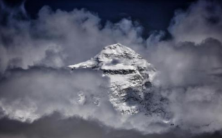
图为世界第一高峰珠穆朗玛峰。西藏被誉为“世界屋脊”“地球第三极”,野生动植物资源、矿产资源丰富,这里江河纵横、湖泊密布,也被誉为“亚洲水塔”。然而由于地处高原,生态环境十分脆弱。西藏和平解放70年来,生态建设和环境保护事业从无到有,不断发展。2020年,中央第七次西藏工作座谈会强调,守护好高原的生灵草木、万水千山,把青藏高原打造成为全国乃至国际生态文明高地。日前,记者走访拉萨、日喀则、那曲、阿里等西藏多地,用镜头记录下了各地自然生态景观。
The picture shows Mount Everest, the world's highest peak. Tibet is known as the "roof of the world" and the "third pole of the earth". It is rich in wildlife and mineral resources. It is also known as the "water tower of Asia" with rivers and lakes. However, due to its location on the plateau, the ecological environment is very fragile. Over the past 70 years since Tibet's peaceful liberation, ecological construction and environmental protection have developed from scratch. In 2020, the seventh Tibet work symposium of the Central Committee stressed that we should protect the living plants and mountains of the plateau and build the Qinghai Tibet Plateau into a highland of national and even international ecological civilization. Recently, the reporter visited Lhasa, Shigatse, Naqu, Ali and other places in Tibet and recorded the natural ecological landscape with the lens.

世界第一高峰珠穆朗玛峰。 李雪峰 摄
The world's highest peak, Mount Everest. Photo by Li Xuefeng

那曲市申扎县境内的湿地。李雪峰 摄
Wetland in Shenza County, Naqu city. Photo by Li Xuefeng

那曲市申扎县境内的湿地。李雪峰 摄
Wetland in Shenza County, Naqu city. Photo by Li Xuefeng

日喀则江萨国家湿地公园。贡嘎来松 摄
Xigaze Jiangsa National Wetland Park. Gongga laisong photo

西藏阿里地区日土县境内的黑颈鹤。 贡嘎来松 摄
Black necked Crane in Ritu County, Ali Prefecture, Tibet. Gongga laisong photo

航拍拉萨市尼木县县城。贡嘎来松 摄
Aerial photography of Nimu County, Lhasa city. Gongga laisong photo

航拍阿里地区日土县伦珠曲典寺。贡嘎来松 摄
Aerial photography of lunzhu qudian temple, Ritu County, Ali Region. Gongga laisong photo


0 条 评 论 Write a Response